

On this page:
What Are Oceans & Coastal Margins? Ocean Circulation Systems Waves: Engine of Coastal Change Coastal Erosion Erosional Landforms Coastal Deposition Longshore Drift Sea Level Change Coral Reefs & Mangroves Coastal Management Integrated Coastal Zone Management ConclusionStand at the edge of any coastline and watch the waves. They look peaceful. Rhythmic. Almost harmless. But those same waves are slowly carving cliffs, swallowing beaches, reshaping entire coastlines, and with rising sea levels, millions of people living near the shore are facing a future that looks nothing like the past. Oceans and coastal margins are not just beautiful landscapes. They are dynamic systems where physical forces and human decisions collide. For Geography, understanding this unit means understanding one of the most contested and vulnerable environments on Earth.
Oceans cover approximately 71% of the Earth's surface and contain 97% of all water on the planet. They regulate climate, support biodiversity, enable global trade, and provide food and livelihoods for billions of people. A coastal margin is the zone where land and ocean meet. It is not a single line; it is a dynamic transition zone that includes beaches, cliffs, estuaries, deltas, coral reefs, and mangrove forests. This zone is constantly changing due to natural processes and human activity. Coasts are among the most densely populated areas on Earth. Over 40% of the world's population lives within 100 km of a coastline, making coastal management one of geography's most urgent challenges.
Surface ocean currents are driven by wind patterns, Earth's rotation (the Coriolis effect), and differences in water temperature and salinity. They move in large circular patterns called gyres — clockwise in the Northern Hemisphere and counterclockwise in the Southern Hemisphere. These currents play a critical role in regulating the global climate. The Gulf Stream, for example, carries warm water from the Gulf of Mexico northward toward Europe, keeping countries like the UK significantly warmer than their latitude would suggest.
Deep ocean circulation is driven by differences in water temperature and salinity, which is why it is called thermohaline circulation (thermo = heat, haline = salt). Cold, salty water is denser and sinks. Warm, less salty water rises. This creates a slow but powerful global conveyor belt, sometimes called the Ocean Conveyor Belt, that moves heat energy around the planet and influences weather patterns on every continent. Disruption of thermohaline circulation due to melting ice and freshwater influx is one of the more serious potential consequences of climate change.
Almost everything that happens at a coastline begins with waves. Understanding how they form and behave is fundamental to this unit.
How Waves Form: Waves are generated by wind blowing over the ocean surface. The size and energy of a wave depend on three factors: wind speed, wind duration, and fetch (the distance of open water over which the wind blows). A longer fetch means more powerful waves.
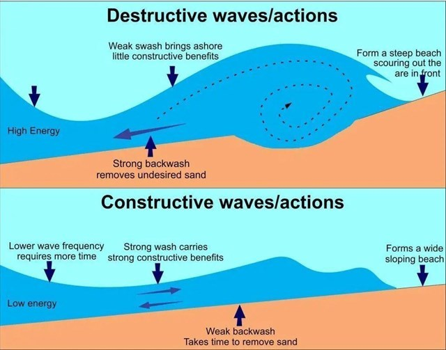
Low-energy waves with a strong swash (water moving up the beach) and weak backwash (water retreating). They build up beaches by depositing sediment. Typical in sheltered bays.
High-energy waves with a weak swash and powerful backwash. They erode the coastline, pulling material back into the sea. Common on exposed headlands and during storms.
Wave Refraction: When waves approach a coastline at an angle, they bend; this is wave refraction. Energy concentrates on headlands (causing erosion) and disperses in bays (causing deposition). This is why headlands are rocky and eroded, while bays tend to have beaches.
Erosion is the process by which waves remove and transport material from the coastline. It happens through four main mechanisms:
Headlands and Bays: Where coastlines have alternating bands of hard and soft rock, the sea erodes soft rock faster, creating bays, while harder rock resists erosion and juts out as headlands.
Cliffs and Wave-Cut Platforms: Waves attack the base of a cliff, cutting a wave-cut notch. As the notch deepens, the cliff collapses, retreating inland and leaving a flat rocky surface called a wave-cut platform.
Caves, Arches, Stacks, and Stumps: These form in sequence on headlands. Waves exploit a weakness and carve a cave. Two caves meeting through a headland form an arch. When an arch roof collapses, an isolated rock pillar called a stack remains. Further erosion reduces the stack to a low stump. The Old Harry Rocks in Dorset, England, are a classic example.
Not all coastal processes remove material. Waves, currents, and wind also deposit sediment, creating new landforms.
Longshore drift is the process by which sediment is transported along a coastline. Waves approach the shore at an angle, pushing sediment diagonally up the beach with the swash. The backwash pulls sediment straight back down the slope. Over many cycles, sediment gradually zigzags along the coast in the direction of the prevailing wind. Longshore drift is responsible for building spits, bars, and tombolos, and is a major challenge for coastal managers.
Eustatic Change: Global change in the actual volume of seawater. When glaciers and ice caps melt, more water enters the ocean, raising sea levels worldwide. Current sea level rise is primarily eustatic, driven by climate change and thermal expansion of warming ocean water.
Isostatic Change: Local change in the height of the land relative to the sea. When ice sheets melt, the land they pressed down slowly rebounds upward (isostatic rebound). Parts of Scandinavia are still rising following the last ice age.
Consequences of Rising Sea Levels: Increased coastal flooding, saltwater intrusion into freshwater supplies, erosion of beaches and protective barriers, and permanent inundation of low-lying land. Small island nations like the Maldives and Tuvalu face existential threats.
Among the most biodiverse ecosystems on Earth. They protect coastlines by absorbing wave energy, support fisheries, and drive tourism. Coral bleaching occurs when water temperatures rise and corals expel the algae living in their tissues, turning white and becoming vulnerable. The Great Barrier Reef has experienced repeated mass bleaching events.
Mangrove forests grow in tropical and subtropical coastal areas. Their dense root systems stabilize shorelines, reduce erosion, absorb storm surge energy, and provide nursery habitats. They are significant carbon stores. Despite their value, mangroves are being destroyed for shrimp farming and coastal development.
As coastlines erode and sea levels rise, communities must decide how to respond. Two broad approaches: hard engineering and soft engineering.
ICZM is a holistic management approach that coordinates different stakeholders — governments, communities, environmental groups, and businesses — to manage the entire coastal zone sustainably. Rather than protecting individual sections of coast in isolation, ICZM considers the coast as a connected system.
Coastlines are not permanent. They never were. Waves erode, currents deposit, sea levels rise, and ecosystems shift, all on timescales from days to millennia. What has changed is the speed at which human activity is accelerating these processes, and the scale of human exposure to their consequences. For Geography students, the oceans and coastal margins unit is not just about memorizing landforms. It is about understanding a system under pressure — where physical geography, human geography, and environmental management intersect in ways that will define the futures of millions of people living at the water's edge.
The waves keep coming. The question is what we choose to do about it.