

The ground beneath your feet feels solid. Permanent. Reliable. It is none of those things. Every year, earthquakes, volcanic eruptions, and tsunamis remind us that the Earth is not a stable platform for human life; it is a dynamic, restless system that was never designed around human convenience. And every year, the gap between where these events happen and how badly they hurt people reveals something important: geophysical hazards are natural, but disasters are not.
A geophysical hazard is a naturally occurring physical process or event that poses a threat to human life, property, or the environment. The keyword is threat; a volcanic eruption in an uninhabited region is a geological event, not a hazard. It becomes a hazard when people are in its path. The main geophysical hazards are: earthquakes, volcanic eruptions, tsunamis, and mass movements (landslides). All of these originate from processes deep within the Earth, making them fundamentally different from hydrometeorological hazards like floods or hurricanes, which are driven by atmospheric conditions.
To understand geophysical hazards, you first need to understand plate tectonics — the theory that Earth's outer shell (the lithosphere) is broken into large pieces called tectonic plates that move slowly over the semi-molten layer beneath (the asthenosphere). There are around 15 major tectonic plates. They move at rates of 2 to 15 centimeters per year, roughly the speed at which your fingernails grow. Slow, but powerful enough to build mountain ranges, open oceans, and trigger some of the most destructive events in human history.
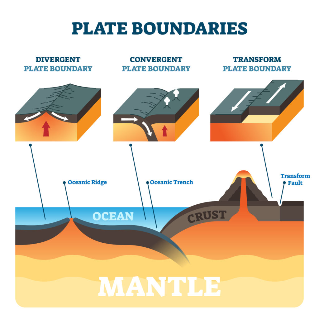
Plates move toward each other. When an oceanic plate meets a continental plate, the denser oceanic plate subducts. Creates deep ocean trenches, volcanic mountain chains, and powerful earthquakes. Example: The Andes and Pacific Ring of Fire.
Plates move apart. Magma rises to fill the gap, creating new crust. Volcanic activity is common but less explosive. Example: Mid-Atlantic Ridge; Iceland sits directly on it.
Plates slide horizontally past each other. No crust created or destroyed, but friction builds stress released as earthquakes. Example: San Andreas Fault in California.
What Causes an Earthquake? Earthquakes occur when stress built up along fault lines is suddenly released, sending seismic waves through the Earth. The point underground where the earthquake originates is the focus (hypocenter). The point on the surface directly above is the epicenter, where shaking is typically strongest.
Measurement scales: The Richter Scale measures magnitude (logarithmic; each whole number represents ten times more ground motion). The Modified Mercalli Scale measures intensity of shaking at a specific location, varying with distance and local geology.
Primary effects: building collapse, ground rupture, casualties. Secondary effects: fires, tsunamis, landslides, disease outbreaks, economic disruption.
The Haiti earthquake of January 2010 measured magnitude 7.0 and killed an estimated 230,000 people. A magnitude 6.3 earthquake in Christchurch, New Zealand, the following year killed 185 people. The difference was not the size of the earthquake. It was the vulnerability of the population. Haiti's poorly constructed buildings, lack of emergency services, extreme poverty, and weak governance meant that a moderate earthquake became one of the deadliest disasters of the 21st century. New Zealand's strict building codes, early warning systems, and emergency preparedness infrastructure meant a similar event caused a fraction of the casualties. This contrast is one of the most important lessons in the entire hazards unit.
How do volcanoes form? Magma from the Earth's mantle reaches the surface at convergent boundaries (subduction zones), divergent boundaries, and hotspots (e.g., Hawaiian Islands).
Gently sloping sides, low-viscosity runny lava. Rarely explode violently. Example: Mauna Loa (Hawaii). Less immediately dangerous but can bury large areas.
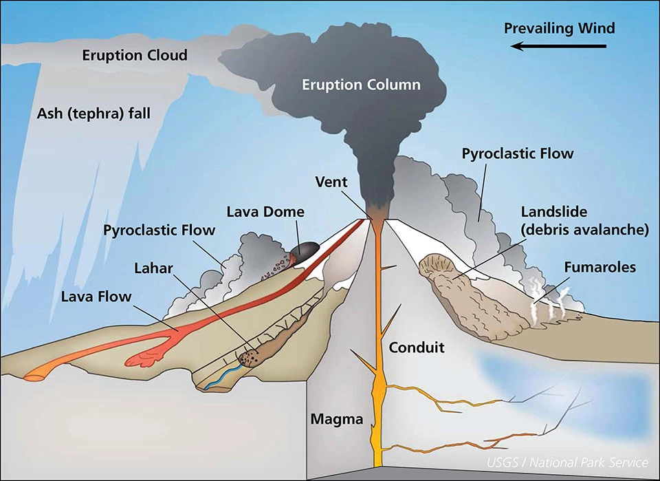
Steep sides built from alternating ash and lava. High-viscosity magma traps gas, causing explosive eruptions. Examples: Mount Pinatubo, Mount St. Helens.
Volcanic hazards: lava flows, pyroclastic flows (superheated clouds up to 700 km/h, deadliest), tephra (ash disrupting aviation and collapsing roofs), volcanic gases (sulfur dioxide can cool global climate), and lahars (volcanic mudflows).
The 1991 eruption of Mount Pinatubo in the Philippines was one of the 20th century's largest volcanic events. It ejected so much sulfur dioxide into the stratosphere that global temperatures dropped by approximately 0.5 degrees Celsius for two years. Despite its enormous power, only around 800 people died because Philippine volcanologists successfully predicted the eruption and coordinated the evacuation of over 60,000 people in advance. This remains one of the most successful volcanic disaster responses in history.
A tsunami is a series of ocean waves generated by sudden, large-scale displacement of water, most commonly an undersea earthquake at a subduction zone. In the open ocean, tsunami waves travel up to 800 km/h but may be less than a meter high. As they approach shallow coastal waters, they slow and increase dramatically in height through shoaling.
Natural warning signs: strong earthquake felt near coast, unusual withdrawal of the sea from the shoreline, a roar from the ocean. The Pacific Tsunami Warning System uses seismometers and DART buoys. The 2004 Indian Ocean Tsunami killed over 230,000 people across 14 countries; since then, warning infrastructure has been significantly expanded.
Mass movements (mass wasting) are the downslope movement of rock, soil, and debris under gravity. They include landslides, mudflows, debris flows, rockfalls, and slumps. Often triggered by earthquakes, heavy rainfall, or volcanic activity. The 1970 Ancash earthquake in Peru triggered a massive rockslide that buried the town of Yungay, killing approximately 25,000 people.
A hazard becomes a disaster when a vulnerable population is exposed to it. Risk is the probability that a hazard will cause harm. Vulnerability is shaped by economic factors (poverty limits housing quality), political factors (weak governance means poor building codes), social factors (marginalized communities face greater risk), and geographic factors (living in high-risk zones). Capacity refers to the resources and systems a community has to cope. The Pressure and Release Model shows that disasters occur at the intersection of a physical hazard and social vulnerability. Reducing disaster risk means reducing vulnerability — a political and economic challenge.
Prediction and Monitoring: Seismometers detect ground movement; probabilistic forecasts identify high-risk zones. Volcano monitoring uses seismometers, tiltmeters, and gas sensors. Tsunami warning systems use seismic data and ocean pressure sensors.
Preparedness and Mitigation: Earthquake-resistant building design (flexible foundations, base isolators), land use planning, public education and evacuation drills, stockpiling emergency supplies, lahar diversion channels.
Response and Recovery: Immediate response includes search and rescue, medical treatment, food and shelter. Long-term recovery rebuilds infrastructure and livelihoods, ideally "building back better" with reduced vulnerability. International aid organizations (e.g., UN OCHA) coordinate responses, but effectiveness depends on local governance and stability.
Development reduces disaster risk. Wealthier countries with strong institutions, enforced building codes, functioning emergency services, and educated populations consistently suffer fewer deaths from geophysical events of equivalent magnitude than poorer countries. Japan experiences more earthquakes than almost any other country, yet its death tolls are consistently low due to decades of investment in earthquake-resistant infrastructure and public preparedness culture. Wealth does not eliminate risk, but it fundamentally changes outcomes. The goal of sustainable hazard management is not just to respond to disasters after they happen, but to reduce the conditions that turn natural events into human tragedies.
The Earth will keep moving. Plates will keep shifting, magma will keep rising, and faults will keep releasing their stored energy. That part is not negotiable. What is negotiable is how prepared we are, how we build our cities, how we govern our communities, and how seriously we take the evidence that tells us where the next event is likely to occur. Geophysical hazards are natural processes. The scale of suffering they cause is, in large part, a human choice. For Geography students, that is the most important idea this entire unit asks you to hold: between the hazard and the disaster, there is always a human decision.